Qeshm Island
Qeshm Island is located in southern Iran in the Persian Gulf. It is 120 km long, and has an average width of 20 km. The island is part of the Zagros Mountains, and it is the largest island in the Persian Gulf. From the point of view of natural phenomena, the island enjoys a special status. Harra mangroves are located in the northern part of the island, and form the habitat for many rare and endangered species of plants and animals. On the southern part, there is a large sea-turtle nesting habitat. The island’s phenomena have been recorded as part of UNESCO’s Man and the Biosphere (MAB) Program. There is also a wide variety of geological phenomena on Qeshm Island.These include a range of landforms.
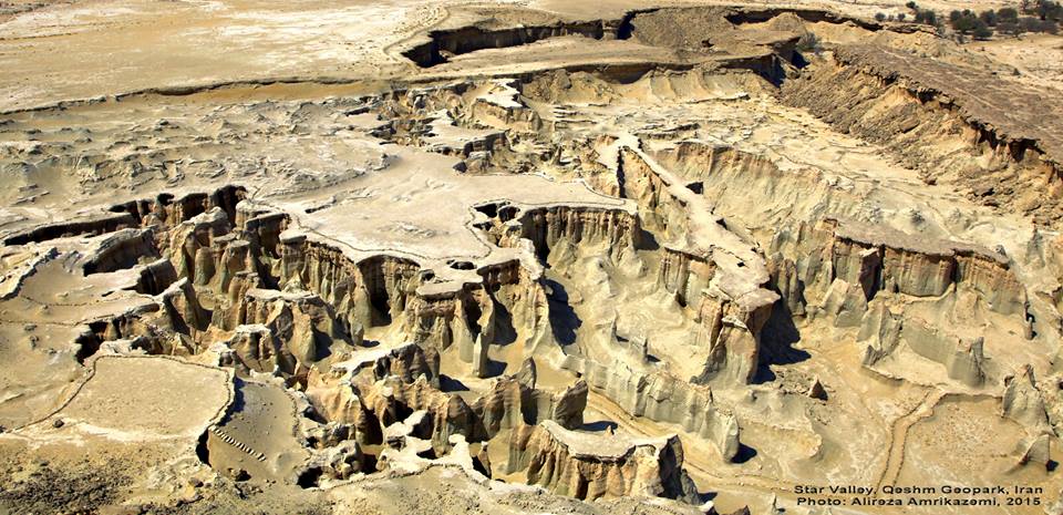
The Kharbas coastal caves have been formed in clay and marl beds. Originally they were formed as the result of wave action, and they are deep and interconnected. They have been extended by humans, and were probably used by the ancient residents of the island as a shelter against enemy attacks. Across the whole of the island there is a wide variety of landforms created by erosion. An example of a scenic vista caused by erosion is found at Darreh-e- Setarehha (the Valley of Stars) on the southern side of the island. Due to the variety of geological formations in the area, especially a limy sandstone whose amount of calcite varies in different parts, the erosion has created many heterogeneous and dissimilar forms.There is a main valley with some tributaries where columns, strip-like walls and arches are abundant, and other landforms create an unusual picturesque landscape. The valley is an ideal place for the study of different types of erosion. The Queshm Roof is a high plateau that stretches along the north–central area of the island. It is predominantly made up of limestone, and is more resistant to erosion than its surrounding formations. The short-term growth of plants after rainfall creates novel scenery in this hot and dry region.
The Chahkuh valley and a similar one nearby have U-shaped profiles. The mouth of the Chahkuh Valley is wide and surrounded by high walls, but its width gradually decreases until it becomes very narrow. The walls are very high and there is little light. Water erosion and dissolution have created long and deep clefts in the shape of concave, spoon-like spherical holes. At the mouth of the valley there are some shallow wells, forming a place for the rain to be stored, and because of the hot and dry weather the stored fresh water has a high value. It seems that this valley and similar vales nearby are related to a large anticline, which has played a key role in the formation of the Namakdan salt dome. This dome, in the southern part of the island, has created various phenomena, and has had a big influence in shaping the morphology of the area, largely through its deposits of iron compounds such as hematite and oligist.The walls of this mountain are rough and jagged, and consist of a variety of stones and ores. In part of the mountain there is a salt cave, which has been formed as the result of salt dissolution.
The cave is about 200 m long, with cavernous phenomena such as saline stalactites and columns. Beside the cave there is a spring of saturated salty water, which deposits salt and hematite in its path and has formed a red and white strip in the area. Other phenomena on the south coast include vast and flat coastal lowlands covered in long ripple marks with bright, thin particles of oligist. In addition there is a rocky coastline and colorful coral reefs.
Alireza Amrikazemi & Abbas Mehrpooya
Ross Dowling, David Newsome (2006). Geotourism, Publishe by Elsevier, PP 90-91.